published Jan 2009
The Universal Trail Assessment Process helps Cornelia, Georgia receive recreational trails funding for trail improvements.
posted Feb 19, 2018
by
Peter Axelson with Beneficial Designs, Inc.,
Brandon Ross with City of San Antonio Parks and Recreation Department,
Nathan Tolbert with Beneficial Designs, Inc.
This program will provide an overview of the needs and processes surrounding assessments of trails and outdoor constructed features.
published Jan 2019
by
American Trails Staff
Low water crossings are designed to allow normal flow under the trail, and to be over-topped during seasonal floods.
posted Aug 14, 2018
The one-mile trail provides a chance to enjoy the natural world at Silvio O. Conte National Fish and Wildlife Refuge.
posted Dec 29, 2017
Accessible trail in the city of Middleton along a pond and wetlands includes boardwalks, a fishing pier, and an accessible launch facility for kayaks and canoes.
published Jun 2018
The beauty of hiking is that it is for all abilities. Opportunities for accessible trails as well as more challenging routes can be found in every corner of America.
published Jan 2018
by
R. Brian Kermeen with USDA Forest Service
Like most areas managed by the Forest Service, U.S. Department of Agriculture, the central Sierra Nevada has steep and mountainous terrain. Most of our facilities evolved over time or were designed 30 years ago with no consideration for the needs of persons with disabilities.
published Dec 2019
by
American Trails Staff
Specific skills used in Interpreting regulations and legislation; applying federal laws on environmental, historic issues; providing accessible routes under the Americans with Disabilities Act; developing and enforcing trail regulations; responding to legal and liability issues.
posted Dec 29, 2017
This project involved resurfacing of the entire 34 miles of the Northern Rail Trail in Merrimack County.
posted Mar 26, 2018
The trail is located on the Pondicherry Division of the Silvio O. Conte National Wildlife Refuge and is universally accessible. It includes a 900 foot long raised boardwalk with rest stops that offer extraordinary views of a boreal forest and wetland communities.
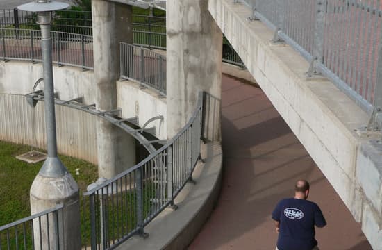
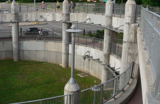
Circular ramp leads runners, strollers, and cyclists from Pfluger Bridge down to trail on north side of Lady Bird Lake (formerly Town Lake), Austin, Texas
Circular ramp leads runners, strollers, and cyclists from Pfluger Bridge down to trail on north side of Lady Bird Lake (formerly Town Lake), Austin, Texas
Circular ramp leads runners, strollers, and cyclists from Pfluger Bridge down to trail on north side of Lady Bird Lake (formerly Town Lake), Austin, Texas
Circular ramp leads runners, strollers, and cyclists from Pfluger Bridge down to trail on north side of Lady Bird Lake (formerly Town Lake), Austin, Texas
Circular ramp leads runners, strollers, and cyclists from Pfluger Bridge down to trail on north side of Lady Bird Lake (formerly Town Lake), Austin, Texas
Circular ramp leads runners, strollers, and cyclists from Pfluger Bridge down to trail on north side of Lady Bird Lake (formerly Town Lake), Austin, Texas


